Archive for the ‘004/ Environment’ Category
Wind Drawings


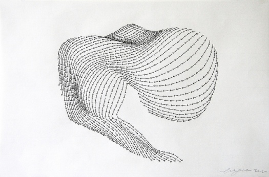
Artist and architect Peter Jellitsch created this series of pen and ink drawings entitled STB based on algorithms that predict how air will move through highrise buildings.
STB means Streambody, this series is based on a motion algorithm that is used in architectural practice to simulate wind directions and the force of air that arrives at highrise buildings. I have experimented with this program, and the outcome was solid bubbles which I have then redrawn with the directions that they had. The degree denotation that my title has (for example: STB/S02/90°) is explaining the turn of the wind-force hitting the object.
 Ink on tracing paper 33 x 28 cmSTB is an amazing ink drawing series created by Peter Jellitsch, Vienna. I really like their looks, remind me of some info-graphics.Jellitsch tells us interesting information about this series;STB means Streambody, this series is based on a motion algorithm that is used in architectural practice to simulate wind directions and the force of air that arrives at highrise buildings. I have experimented with this program, and the outcome was solid bubbles which I have then redrawn with the directions that they had. The degree denotation that my title has (for example: STB/S02/90°) is explaining the turn of the wind-force hitting the object.” See more;Peter Jellitsch is a a 29 year old phd student from Vienna where he did a master in architecture at the Academy of Fine Arts in Vienna. Jellitsch is practicing somewhere between art, architecture and science.“Generally I am trying to translate digital generated stuff into analog drawings. On one hand to see which differences appear between the digital outcome and the analog one, and on the other hand, i am interested in the repetitive movements that appear when i am reproducing from digital data. My work is always repititve in terms of sequences of one project. always a series of drawings, because most of my experiments are based on digital simulations.”
Ink on tracing paper approx. 33 x 28 cm
Ink on Paper 40,5 x 26 cm
Ink on Paper 40,5 x 26 cm


Vent Stack
From BLDGBLOG

[Image: The Holland Tunnel Land Ventilation Building].
… and sometimes in the heart of the city. After all, there are also weather systems artificially generated inside the earth by construction projects and large-scale pieces of urban infrastructure, whole subterranean climatologies of moving air that would not otherwise exist without the implanting hand of architecture, as if surgically grafted there. Atmospheric cut-and-cover. A weather reserve beneath the sidewalk.
In any case, the idea that a region’s climate—its seasonal weather systems and thermal particularities—might become something more than mere background through a simple act of musicalization—that you could install Sauvageot orchestras in places all over the world to turn storms into symphonies—is amazingly suggestive for future design projects. From low-pressure systems in central Russia to the Santa Ana winds of suburban Los Angeles, architecture becomes a musical generator, an acoustic ornament activated by the sky.
Scanning the Mist


We have been speculating on the capabilities of 3D scanning.
We thought it might be interesting to see if the scanner could detect smoke and mist. It did and here are the remarkable results! These scans acted as a test for the later site specific work ‘Slow Becoming Delightful.’


Desert Aqua-Net Plan
From: SHIMIZU CORPORATION
Creating Lakes in the Desert: A Proposal for Creating a Network of Canals and Exploring New Ways to Inhabit Our Planet
The Desert Aqua-Net Plan is a concept for making use of the desert, which currently accounts for some one-third of the Earth’s total land area.
According to this idea, multiple manmade lakes will be created in depressed areas of deserts, after which artificial islands will be built on the lakes. Filled with seawater introduced through canals, the lakes will then be connected to form a water network.
By creating waterways in the desert and transforming arid and semiarid areas into inhabitable land, this plan (which is still in the simulation stage) ultimately seeks to build cities on manmade islands that have been formed on seawater lakes.

Mersey Tornado
From: Pruned

As part of the 2012 Cultural Olympiad, artist Anthony McCall will be spinning an artificial, mile high tornado in Liverpool. Called Column, this swirling micro-climate will be created “by gently rotating the water on the surface of the [River] Mersey and then adding heat which will make it lift into the air like a water spout or dust devil.”
Outside with the “[in]coherent convection” of the elements and without the controlled environment of some cavernous atriums, no doubt McCall and his engineering team will encounter some complications. But we’re hoping the final piece will look as legible as the image, or at least on favorable days.

Microclimate
A microclimate is a local atmospheric zone where the climate differs from the surrounding area. The term may refer to areas as small as a few square feet (for example a garden bed) or as large as many square miles (for example a valley). Microclimates exist, for example, near bodies of water which may cool the local atmosphere, or in heavily urban areas where brick, concrete, and asphalt absorb the sun’s energy, heat up, and reradiate that heat to the ambient air: the resulting urban heat island is a kind of microclimate.
Another contributing factor to microclimate is the slope or aspect of an area. South-facing slopes in the Northern Hemisphere and north-facing slopes in the Southern Hemisphere are exposed to more direct sunlight than opposite slopes and are therefore warmer for longer.
The area in a developed industrial park may vary greatly from a wooded park nearby, as natural flora in parks absorb light and heat in leaves, that a building roof or parking lot just radiates back into the air. Advocates of solar energy argue that widespread use of solar collection can mitigate overheating of urban environments by absorbing sunlight and putting it to work instead of heating the foreign surface objects.[citation needed]
A microclimate can offer an opportunity as a small growing region for crops that cannot thrive in the broader area; this concept is often used in permaculture practiced in northern temperate climates. Microclimates can be used to the advantage of gardeners who carefully choose and position their plants. Cities often raise the average temperature by zoning, and a sheltered position can reduce the severity of winter. Roof gardening, however, exposes plants to more extreme temperatures in both summer and winter.
Tall buildings create their own microclimate, both by overshadowing large areas and by channelling strong winds to ground level. Wind effects around tall buildings are assessed as part of a microclimate study.
Microclimates can also refer to purpose made environments, such as those in a room or other enclosure. Microclimates are commonly created and carefully maintained in museum display and storage environments. This can be done using passive methods, such as silica gel, or with active microclimate control devices.
San Francisco is a city with microclimates and submicroclimates. Due to the city’s varied topography and influence from the prevailing summer marine layer, weather conditions can vary by as much as 9°F (5°C) from block to block. [1]
The region as a whole, known as the San Francisco Bay area can have a wide range of extremes in temperature. In the basins and valleys adjoining the coast, climate is subject to wide variations within short distances as a result of the influence of topography on the circulation of marine air. The San Francisco Bay Area offers many varieties of climate within a few miles. In the Bay Area, for example, the average maximum temperature in July is about 64 °F (18 °C) at Half Moon Bay on the coast, 87 °F (31 °C) at Walnut Creek only 25 miles (40 km) inland, and 95 °F (35 °C) at Tracy, just 50 miles (80 km) inland. [2]
The Los Angeles and San Diego areas are also subject to phenomena typical of a microclimate. As such, the temperatures can vary as much as 18°F (-8°C) between inland areas and the coast, with a temperature gradient of over one degree per mile (1.6 km) from the coast inland. Southern California has also a weather phenomenon called “June Gloom or May Grey”, which sometimes gives overcast or foggy skies in the morning at the coast, but usually gives sunny skies by noon, during late spring and early summer.
Calgary, Alberta is also known for its microclimates. Especially notable are the differences between the downtown and river valley/flood plain regions and the areas to the west and north. This is largely due to an elevation difference within the city’s boundaries of over 1000 ft, but can also be attributed somewhat, to the effects of the seasonal Chinooks. [3]
Halifax, Nova Scotia also has numerous microclimates. Coastal temperatures and weather conditions can differ considerably from areas located just 5-15km inland. This is true in all seasons. Varying elevations are common througout the city, and it is even possible to experience several microclimates while travelling on a single highway due to these changing elevations.
Santiago, Chile is also subject to microclimates, but is not as well known for it.
Known for its wines, the Ticino region in Switzerland benefits from a microclimate in which palm trees and banana trees grow.
Gran Canaria is called “Miniature Continent” for its rich variety of microclimates.
Cloudy with a Chance of Certainty
As part of the exhibition, ‘The Last Newspaper,’ at the New Museum.
Weather is important news. A Ford Foundation-sponsored 2006 survey found that people regard the weather as the news of greatest concern (followed by national and international events). The high demand for weather information is confirmed by a Pew Research Center study in which it ranks among the news categories of most interest consistently for the past three decades. Weather is even news that is highly sought after online. The Weather Channel’s http://www.weather.com is one of the top fifteen most visited sites, having about the same amount or more traffic than major sources of general news, like CNN, the New York Times, MSNBC, and the BBC.
But even though it is a matter of interest, weather reporting is rarely a matter of consequence. We are interested in knowing climatic conditions because they impact us directly. The weather personally affects what we wear, our commute, how the workday goes, and what we do on weekends; and being aware of what the weather will be let’s us plan accordingly. Yet, some would consider it not news at all because unlike the reporting of world affairs, politics, economics, the war or health, the daily reporting of weather isn’t information about events of great consequence. The reported facts are immediately relevant though they bear little significance on the larger course of human interactions. But that’s not to say that the weather itself is unimportant.
Although we spend a lot of time following weather news, there isn’t a lot of news about the consequences of weather. Only when meteorological pressures depart from slight fluctuations and approach extremes that potentially cause damage does weather reporting describe its collective impact. Yet, the weather greatly affects us everyday and our project, Cloudy With a Chance of Certainty, presents an ongoing report of the consequences of its unpredictability on cities. Weather influences the workings of cities, altering the flow of their traffic infrastructure, the use of their energy resources, and the productivity of their industries. Knowing what the weather will be helps cities to prepare for climatologic surprises and minimize disruption. However, even with advanced technological forecasting, the weather is uncertain and our hazy knowledge of the situation has meaningful urban costs as shown in the three display panels. Panel One provides the current temperature of twenty-four US cities. Panel Two represents short-term weather uncertainty expressed by the change in the daily closing price for Chicago Mercantile Exchange Weather Futures traded for each of the cities over one month, along with the sum of the difference between each city’s daily forecasted and actual temperature for one month. Panel Three provides a preliminary estimate of the cities’ GDP output based upon the affects of weather changes on utilities, communication, construction, manufacturing, wholesale trade, agriculture, mining, and ‘financial, insurance, and real estate’ sectors.
Credit: Jeffrey Inaba / C-Lab
Reforestation of the Thames Estuary

While studying at the Bartlett School of Architecture in London, recent graduate Tom Noonan produced a series of variably-sized hand-drawings to illustrate a fictional reforestation of the Thames estuary.

Stewarding, but also openly capitalizing on, this return of woodsy nature is the John Evelyn Institute of Arboreal Science, an imaginary trade organization (of which we will read more, below).

The urban scenario thus outlined—imagining a “future timber and plantation industry” stretching “throughout London, and beyond”—is like something out of Roger Deakin’s extraordinary book Wildwood: A Journey Through Trees (previously described here) or even After London by Richard Jeffreys.
In that latter book, Jeffreys describes a thoroughly post-human London, as the ruined city is reconquered by forests, mudflats, aquatic grasses, and wild animals: “From an elevation, therefore,” Jeffreys writes, “there was nothing visible but endless forest and marsh. On the level ground and plains the view was limited to a short distance, because of the thickets and the saplings which had now become young trees… By degrees the trees of the vale seemed as it were to invade and march up the hills, and, as we see in our time, in many places the downs are hidden altogether with a stunted kind of forest.”
Noonan, in a clearly more domesticated sense—and it would have been interesting to see a more ambitious reforestation of all of southeast England in these images—has illustrated an economically useful version of Jeffreys’s eco-prophetic tale.

[Image: “Lecture Preparations” by Tom Noonan, courtesy of the architect].
From Noonan’s own project description:
- The reforestation of the Thames Estuary sees the transformation of a city and its environment, in a future where timber is to become the City’s main building resource. Forests and plantations established around the Thames Estuary provide the source for the world’s only truly renewable building material. The river Thames once again becomes a working river, transporting timber throughout the city.
It is within these economic circumstances that the John Evelyn Institute of Arboreal Science can establish itself, Noonan suggests:
- The John Evelyn Institute of Arboreal Scienc eat Deptford is the hub of this new industry. It is a centre for the development and promotion of the use of timber in the construction of London’s future architecture. Its primary aim is to reintroduce wood as a prominent material in construction. Through research, exploration and experimentation the Institute attempts to raise the visibility of wood for architects, engineers, the rest of the construction industry and public alike. Alongside programmes of education and learning, the landscape of the Institute houses the infrastructure required for the timber industry.
 [
[
And the Institute requires, of course, its own architectural HQ.

Noonan provides that, as well. He describes the Institute as “a landscape connecting Deptford with the river,” not quite a building at all. It is an “architecture that does not conform to the urban timeframe. Rather, its form and occupation is dependent on the cycles of nature.”
- The architecture is created slowly—its first years devoid of great activity, as plantations mature. The undercroft of the landscape is used for education and administration. The landscape above becomes an extension of the river bank, returning the privatised spaces of the Thames to the public realm. Gaps and cuts into the landscape offer glimpses into the monumental storage halls and workshops below, which eagerly anticipate the first log harvest. 2041 sees the arrival of the first harvest. The landscape and river burst in a flurry of theatrical activity, reminiscent of centuries before. As the plantations grow and spread, new architectures, infrastructures and environments arise throughout London and the banks of the Thames, and beyond.
The drawings are extraordinary, and worth exploring in more detail, and—while Noonan’s vision of London transformed into a working forest plantation would have benefitted from some additional documentation, such as maps*—it is a delirious one.

Considering the ongoing overdose of urban agriculture imagery passing through the architecture world these days, it is refreshing simply to see someone hit a slightly different note: to explore urban forestry in an aesthetically powerful way and to envision a world in which the future structural promise of cultivated plantlife comes to shape the city.
Phytoremediation
From Brownfields to Greenfields: A Field Guide to Phytoremediation
|
by Kaja Kühl
November 10th, 2010 |
Underutilized or vacant space in the city can be a source of creative inspiration for urban agriculture, public parks, housing, community space, and the occasional mini-golf course. But prior to any contemplation of productive interventions into these sites, their environmental health and safety must be considered. Contaminated lots are known as brownfield sites, and the remediation necessary before development can take place is often a lengthy and expensive process. In PlaNYC, Mayor Bloomberg has identified brownfield remediation as a key initiative to the healthy development of New York, but urban designer Kaja Kühl (and her fellow researchers Lisa Brunie, Erik Facteau and Jay Tsai) was interested in finding smaller scale, cost-effective approaches to the problem. Here, Kühl presents A Field Guide to Phytoremediation, a handbook on how to remove contaminants from land using plants. Read on, and if you have property that might benefit from this approach, contact Kühl to help turn her research into action. -V.S.

According to the Department of City Planning’s most recent data, 7.1% of New York City’s land is vacant and, for the most part, underutilized. This is a rate much lower than the national average of 15% (in some cities the rate of vacant land is as high as 45%). However, taken together, these properties amount to approximately 11,000 acres of underutilized land — roughly the size of Manhattan (not counting streets). Imagine: across the five boroughs there is enough available land to fill Manhattan, with the potential to grow fresh food, create new parks or build affordable housing. But many of these vacant sites are potentially contaminated by previous industrial uses or leftover building materials, especially lead-based paint. Contamination and the potential health hazards to people who live, work or play on or near such sites become subject to oversight and regulation only in the event of a rezoning permitting residential uses. In those cases, a site receives an e-designation, which identifies it as potentially hazardous due to previous industrial uses. Once designated, site owners are obligated to submit to a process of site investigation and clean up.
 50% of all vacant lots in New York City are smaller than 2,500sf and are owned by individuals. Click to enlarge.
In May of 2009, Mayor Bloomberg signed the New York City Brownfield and Community Revitalization Act, a milestone in the City’s commitment to cleaning up brownfields for productive reuse in accordance with PlaNYC. Citing the scarcity of land in New York City and the anticipated influx of one million new residents by 2030, PlaNYC identified the importance of cleanup and redevelopment of properties that are abandoned and underutilized due to the presence or perceived presence of contamination. As part of this effort, the City has created the Office of Environmental Remediation, which oversees the environmental review of brownfield sites and offers assistance to property owners on the path to a Green Property Certification and potential redevelopment.
50% of all vacant properties in the city are smaller than 2,500sf and individually owned. 80% are smaller than 5,000sf. Remediation, typically in the form of excavation of the contaminated soil, is costly, despite programs, assistance and grants now available. As a result, these small properties lie vacant for years, underutilized and toxic, their value further diminished by the appearance of abandonment and potential contamination.

We created a Field Guide to Phytoremediation to illustrate how property owners can use these years to their advantage and initiate a slow but cost-effective clean-up process using nature as their ally to add 11,000 acres of productive, usable land to the City‘s healthy environment.
Phytoremediation is the use of plants to remove contaminants from the environment. By harnessing the natural capabilities of plants we can remediate toxic soils, groundwater, surface water, and sediments. Phytoremediation is a low-cost alternative to traditional brownfield clean-up. Instead of removing tons of toxic soil and filling the site with new clean soil, plants remove contaminants from the soil and store it within their plant tissue. In some cases, the plants themselves then have to be removed as hazardous waste, other plants break down the toxins and eliminate them altogether.
 Click to enlarge.
Contaminants successfully removed in field studies have included heavy metals, radionuclides, chlorinated solvents, petroleum hydrocarbons, polychlorinated biphenyls (PCBs), pesticides and explosives. In order to successfully remediate toxins in soil or water, the appropriate plant groups have to be planted and monitored. Different plants have different remediative qualities. Plants offer an aesthetic as well as an environmental value to the city beyond the phytoremediation process. Improved air quality and reduction of storm water run-off are among the additional benefits of planting on sites that would otherwise be underutilized until funding for soil removal becomes available.
 The costs associated with remediating lead contamination on a 2,500sf lot through phytoextraction using Indian Mustard can be reduced to 10% of those using common methods of excavation and fill.
.
The steps below describe a one-year process of testing, planting, monitoring and harvesting. Depending on the level of contamination, this cycle can be repeated for several years until levels of metal or PCBs in the soil reach the minimum recommended by the NYS Department of Environmental Conservation.
 |
1. COLLECT A SOIL SAMPLE Gather soil samples by taking them from at least 4 different areas per every 400sf of space. Samples should come from approximately 6 inches below the surface and should not contain any gravel, grass, trash, etc. You can mix the samples to form a composite sample of your entire lot. |
 |
2. SEND IT TO A LAB Brooklyn College and Cornell University provide inexpensive soil testing services (approximately $30 for heavy metal tests). The NY State Department of Health also offers a list of certified professional labson its Wadsworth Center website. Fill a zip-lock bag with your soil and send it to the lab together with information about your site. You will get a report in about 2 weeks. |
 |
3. CREATE A REMEDIATION STRATEGY From the test results, determine if and how you should remediate contaminants. See the chart at the end of this post to determine which plants would best help you clean up your lot and how many you will need. |
 |
4. START PLANTING Most of the seeds you will need are sold online. Sow and germinate them in a small container and water them regularly. Transplant them to your site when they are about 3“ high and after the last spring frost. Manage them as garden plants and watch them grow. |
 |
5. HARVEST AND RE-PLANT After about fourteen weeks, your plants will be saturated with heavy metals, PCBs or other toxins. Harvest the entire plant, including the roots, stems and leaves, and repeat this growing cycle as often as climate permits. |
 |
6. DISPOSE AS HAZARDOUS WASTE Some plants are hyperaccumulators. They store the toxins within their plant tissue and, after this process, will themselves be toxic. Check for the location of the Special Waste Drop-Off site in your borough and dispose of them as hazardous waste. Keep them away from children and animals. |
 |
7. RE-TEST YOUR SOIL At the end of the growing season, re-test the soil to track the improvements. You can also test the plant material if you are curious about the change. Depending on the level of contamination at the site, this planting process may have to be repeated over 2-3 years. |
 |
8. GET A GREEN PROPERTY CERTIFICATION The New York City Office of Environmental Remediation, which oversees the City’s brownfield clean-up program, offers Green Property Certifications. This certificate signifies that a property has been investigated, cleaned, and is protective of both public health and the environment. To qualify, you can sign up for the NYC Brownfield Cleanup Program. |
.
The table below gives examples of levels of acceptable soil contamination for certain recreational, residential or food production uses (as recommended by the NY State Department of Environmental Conservation) and suggests plant material most effective in remediating each contaminant.

.
We would love to help and put this research into action. So, whether you are an individual property owner or community group with little budget but plenty of energy and a vacant lot that might be contaminated, get in touch!
.
This project was originally submitted to the One Prize: From Mowing to Growing competition in May 2010. Lisa Brunie, Erik Facteau and Jay Tsai assisted in research for the field guide.
.
SOURCES:
1. US Environmental Protection Agency. “Re: Contaminant Focus.” Contaminated Site: Clean-Up Information. US EPA Office of Superfund Remediation and Technology Innovation, Washington, DC, 7 Jan. 2010. Web. 22 Apr. 2010.
2. New York State Department of Environmental Conservation. “Re: 375-6-8 Soil Cleanup Objective Tables.” Subpart 375-6: Remedial Program Soil Cleanup Objectives. NYS DEC, Albany, NY, 14 Dec. 2006. Web. 22 Apr. 2010.
3. Wikipedia, The Free Encyclopedia. “Re: Hyperaccumulators Table – 1 and 3.” Redirected from, Phytoremediation, Hyperaccumulators. Wikimedia Foundation, Inc. San Francisco, CA, 14 Apr. 2010. Web 22 Apr. 2010.
4. U.S. EPA. 1996. Soil Screening Guidance: User‘s Guide. Office of Emergency and Remedial Response, Washington, DC. EPA/540/R95/128.
5. Schippers, R.R. & Mnzava, N.A. Brassica juncea (L.) Czern. [Internet] Record from Protabase. van der Vossen, H.A.M. & Mkamilo, G.S. (Editors). PROTA (Plant Resources of Tropical Africa / Ressources végétales de l’Afrique tropicale), Wageningen, Netherlands. 2007. Web. 22 Apr. 2010.
6. Duke, James A. Brassica juncea (L.) Czern. Handbook of Energy Crops. unpublished. Center for New Crops & Plant Products, Purdue University, 1983. Web. 22 Apr. 2010.
7. Shayler, Hannah, Murray McBride and Ellen Harrison. “Re: Guide to Soil Testing and Interpreting Results.” Cornell Waste Management Institute. Department of Crop & Soil Sciences, Ithaca, NY, 15 Apr. 2009. Web. 22 Apr. 2010.
8. Environmental Science Analytical Center. Soil Testing Brochure. Department of Geology, Brooklyn College, Web. 22 Apr. 2010.
9. Washington State Department of Ecology. Dirt Alert – Soil Sampling Guidance for Owners, Operators and Employees of Small Properties Where Children Play. Publication #06-09-099. Olympia, WA, Sep. 1999. Web. 22 Apr. 2010.
10. New York City Department of City Planning (Land use summary, 2007)
11. Michael A. Pagano and Ann O’M. Bowman: Vacant Land in Cities, Brookings Institution Report, 2001
.
Kaja Kühl is an urban designer and principal of youarethecity, a research, design and planning practice interested in creating dialogue about the urban environment. She is an Adjunct Associate Professor at Columbia University.
The views expressed here are those of the author only and do not reflect the position of Urban Omnibus editorial staff or the Architectural League of New York.
Living Architecture
Engineered Bacteria Can Fill Cracks In Aging Concrete

Researchers at the University of Newcastle in the UK have created a new kind of concrete glue that can patch up the cracks in concrete structures, restoring buildings that have been damaged by seismic events or deteriorated over time. But the glue isn’t an adhesive or some kind of synthetic material; the researchers have custom-designed a bacteria to burrow deep into the cracks in concrete where they produce a mix of calcium carbonate and a special bacteria glue that hardens to the same strength of the surrounding concreate.
GPS Pigeon

Conceived by Beatriz da Costa, a professor of arts, computation, and engineering at the University of California, Irvine, PigeonBlog “enlists homing pigeons to participate in a grassroots scientific data gathering initiative designed to collect and distribute information about air quality conditions to the general public. Pigeons are equipped with custom-built miniature air pollution sensing devices enabled to send the collected localized information to an online server without delay. Pollution levels are visualized and plotted in real-time over Google’s mapping environment, thus allowing immediate access to the collected information to anyone with connection to the Internet.”
So rather than remaining an urban nuisance, pigeons coalesce into a network of ambient monitoring devices.
Which makes one wonder what other sort of urban animals can be recruited as bloggers, letting us know the particulars of their day, uploading mobile cam photos to Flickr of street scenes or rush hour traffic on the freeways or that four-alarm fire in downtown, all done in real-time. Can we soon expect stray cats and dogs, sewer rats, and cockroaches to be thought of as critical infrastructure rather than something to be designed out of the landscape?
http://www.pigeonblog.mapyourcity.net/
Experimental Geography: From Cultural Production to the Production of Space
Read at: The Brooklyn Rail by Trevor Paglen

When most people think about geography, they think about maps. Lots of maps. Maps with state capitals and national territories, maps showing mountains and rivers, forests and lakes, or maps showing population distributions and migration patterns. And indeed, that isn’t a wholly inaccurate idea of what the field is all about. It is true that modern geography and mapmaking were once inseparable.
Renaissance geographers like Henricus Martellus Germanus and Pedro Reinel, having rediscovered Greek texts on geography (most importantly Ptolemy’s Geography), put the ancient knowledge to work in the service of the Spanish and Portuguese empires. Martellus’s maps from the late 15th Century updated the old Greek cartographic projections to include Marco Polo’s explorations of the East as well as Portuguese forays along the African coast. Reinel’s portolan maps are some of the oldest modern nautical charts. Cartography, it turned out, was an indispensable tool for imperial expansion: if new territories were to be controlled, they had to be mapped. Within a few decades, royal cartographers filled in blank spots on old maps. In 1500, Juan de la Cosa, who accompanied Columbus on three voyages as captain of the Santa Maria, produced the Mappa Mundi, the first known map to depict the New World. Geography was such an important instrument of Portuguese and Spanish colonialism that early modern maps were some of these empires’ greatest secrets. Anyone caught leaking a map to a foreign power could be punished by death.
In our own time, another cartographic renaissance is taking place. In popular culture, free software applications like Google Earth and MapQuest have become almost indispensable parts of our everyday lives: we use online mapping applications to get directions to unfamiliar addresses and to virtually “explore” the globe with the aid of publicly available satellite imagery. Consumer-available global positioning systems (GPS) have made latitude and longitude coordinates a part of the cultural vernacular. In the arts, legions of cultural producers have been exercising the power to map. Gallery and museum exhibitions are dedicated to every variety of creative cartography; “locative media” has emerged as a form of techno-site-specificity; in the antiquities market, old maps have come to command historically unprecedented prices at auction. Academia, too, has been seized by the new powers of mapmaking: geographical information systems (GIS) have become a new lingua franca for collecting, collating, and representing data in fields as diverse as archaeology, biology, climatology, demography, epidemiology, and all the way to zoology. In many people’s minds, a newfound interest in geography has seized popular culture, the arts, and the academy. But does the proliferation of mapping technologies and practices really point to a new geographic cultural a priori? Not necessarily. Although geography and cartography have common intellectual and practical ancestors, and are often located within the same departments at universities, they can suggest very different ways of seeing and understanding the world.
Contemporary geography has little more than a cursory relationship to all varieties of cartography. In fact, most critical geographers have a healthy skepticism for the “God’s-Eye” vantage points implicit in much cartographic practice. As useful as maps can be, they can only provide very rough guides to what constitutes a particular space.
Geography is a curiously and powerfully transdisciplinary discipline. In any given geography department, one is likely to find people studying everything from the pre-Holocene atmospheric chemistry of northern Greenland to the effects of sovereign wealth funds on Hong Kong real estate markets, and from methyl chloride emissions in coastal salt marshes to the racial politics of nineteenth-century California labor movements. In the postwar United States, university officials routinely equated the discipline’s lack of systematic methodological and discursive norms with a lack of seriousness and rigor, a perception that led to numerous departments being closed for lack of institutional support. The end of geography at Harvard was typical of what happened to the field: university officials shut down its geography
department in 1948, as CUNY geographer Neil Smith tells it, after being flummoxed by their “inability to extract a clear definition of the subject, to grasp the substance of geography, or to determine its boundaries with other disciplines.” The academic brass “saw the field as hopelessly amorphous.” But this “hopeless amorphousness” is, in fact, the discipline’s greatest strength.
No matter how diverse and transdisciplinary the field of geography may seem, and indeed is, a couple of axioms nevertheless unify the vast majority of contemporary geographers’ work. These axioms hold as true for the “hard science” in university laboratories as for human geographers studying the unpredictable workings of culture and society. Geography’s major theoretical underpinnings come from two related ideas: materialism and the production of space.
In the philosophical tradition, materialism is the simple idea that the world is made out of “stuff,” and that moreover, the world is only made out of “stuff.” All phenomena, then, from atmospheric dynamics to Jackson Pollock paintings, arise out of the interactions of material in the world. In the western tradition, philosophical materialism goes back to ancient Greek philosophers like Democritus, Anaxagoras, and Epicurus, whose conceptions of reality differed sharply from Plato’s metaphysics. Later philosophers like Thomas Hobbes, David Hume, Ludwig Feuerbach, and Karl Marx would develop materialist philosophies in contradistinction to Cartesian dualism and German idealism. Methodologically, materialism suggests an empirical (although not necessarily positivistic) approach to understanding the world. In the contemporary intellectual climate, a materialist approach takes relationality for granted, but an analytic approach that insists on “stuff” can be a powerful way of circumventing or tempering the quasi-solipsistic tendencies found in some strains of vulgar poststructuralism.
Geography’s second overarching axiom has to do with what we generally call “the production of space.” Although the idea of the “production of space” is usually attributed to the geographer-philosopher Henri Lefebvre, whose 1974 book La Production de l’Espace introduced the term to large numbers of people, the ideas animating Lefebvre’s work have a much longer history.Like materialism, the production of space is a relatively easy, even obvious, idea, but it has profoundimplications. In a nutshell, the production of space says that humans create the world around them and that humans are, in turn, created by the world around them. In other words, the human condition is characterized by a feedback loop between human activity and our material surroundings. In this view, space is not a container for human activities to take place within, but is actively “produced” through human activity. The spaces humans produce, in turn, set powerful constraints upon subsequent activity.
To illustrate this idea, we can take the university where I’m presently writing this text. At first blush, the university might seem like little more than a collection of buildings: libraries, laboratories, and classrooms with distinct locations in space. That’s what the university looks like on a map or on Google Earth. But this is an exceptionally partial view of the institution. The university is not an inert thing: it doesn’t “happen” until students arrive to attend classes, professors lock themselves away to do research, administrative staff pays the bills and registers the students, state legislators appropriate money for campus operations, and maintenance crews keep the institution’s physical infrastructure from falling apart. The university, then, cannot be separated from the people who go about “producing” the institution day after day. But the university also sculpts human activity: the university’s physical and bureaucratic structure creates conditions under which students attend lectures, read books, write papers, participate in discussions, and get grades. Human activity produces the university, but human activities are, in turn, shaped by the university. In these feedback loops, we see production of space at work.
Fine. But what does all of this have to do with art? What does this have to do with “cultural production?”
Contemporary geography’s theoretical and methodological axioms don’t have to stay within any disciplinary boundaries whatsoever (a source of much confusion at Harvard back in the mid-1940s). One can apply them to just about anything. Just as physical geographers implicitly use the idea of the production of space when they inquire into the relationship between human carbon emissions and receding Antarctic ice shelves, or when human geographers investigate the relationships between tourism on Tanzanian nature preserves, geography’s axioms can guide all sorts of practice and inquiry, including art and culture. A geographic approach to art, however, would look quite different than most conventional art history and criticism. The difference in approach would arise from the ways in which various disciplines rely on different underlying conceptions of the world. A geographer looking into art would begin with very different premises than those of an art critic.

The Salt Pit (Shomali Plains northeast of Kabul, Afghanistan). Photo by Trevor Paglen.
To speak very generally, the conceptual framework organizing much art history and criticism is one of “reading culture,” where questions and problems of representation (and their consequences) are of primary concern. In the traditional model, the critic’s task is to describe, elaborate upon, explain, interpret, evaluate, and critique pre-given cultural works. In a certain sense, the art critic’s role is to act as a discerning consumer of culture. There’s nothing at all wrong with this, but this model of art criticism must (again, in a broad sense) tacitly assume an ontology of “art” in order to have an intelligible starting point for a reading, critique, or discussion. A good geographer, however, might use her discipline’s analytic axioms to approach the problem of “art” in a decidedly different way.
Instead of asking “What is art?” or “Is this art successful?” a good geographer might ask questions along the lines of “How is this space called ‘art’ produced?” In other words, what are the specific historical, economic, cultural, and discursive conjunctions that come together to form something called “art” and, moreover, to produce a space that we colloquially know as an “art world”? The geographic question is not “What is art?” but “How is art?” From a critical geographic perspective, the notion of a free-standing work of art would be seen as the fetishistic effect of a production process. Instead of approaching art from the vantage point of a consumer, a critical geographer might reframe the question of art in terms of spatial practice.
We can take this line of thinking even further. Instead of using geographic axioms to come up with an alternative “interpretive” approach to art (as I suggested in the previous paragraph), we can use them in a normative sense. Whether we’re geographers, artists, writers, curators, critics, or anyone else, we can use geographic axioms self-reflexively to inform our own production.
If we accept Marx’s argument that a fundamental characteristic of human existence is “the production of material life itself” (that humans produce their own existence in dialectical relation to the rest of the world), and, following Lefebvre (and Marx) that production is a
fundamentally spatial practice, then cultural production (like all production) is a spatial practice. When I write an essay such as this, get it published in a book, and put it on a shelf in a bookstore or museum, I’m participating in the production of space. The same is true for producing art: when I produce images and put them in a gallery or museum or sell them to collectors, I’m helping to produce a space some call the “art world.” The same holds true for “geography”: when I study geography, write about geography, teach geography, go to geography conferences, and take part in a geography department, I’m helping to produce a space called “geography.” None of these examples is a metaphor: the “space” of culture isn’t just Raymond Williams’s “structure of feeling” but, as my friends Ruth Wilson Gilmore and Clayton Rosati underline, an “infrastructure of feeling.”
My point is that if one takes the production of space seriously, the concept applies not only to “objects” of study or criticism, but to the ways one’s own actions participate in the production of space. Geography, then, is not just a method of inquiry, but necessarily entails the production of a space of inquiry. Geographers might study the production of space, but through that study, they’re also producing space. Put simply, geographers don’t just study geography, they create geographies.
The same is true for any other field and any other form of practice. Taking this head-on, incorporating it into one’s practice, is what I mean by “experimental geography.”
Experimental geography means practices that take on the production of space in a self-reflexive way, practices that recognize that cultural production and the production of space cannot be separated from each another, and that cultural and intellectual production is a spatial practice. Moreover, experimental geography means not only seeing the production of space as an ontological condition, but actively experimenting with the production of space as an integral part of one’s own practice. If human activities are inextricably spatial, then new forms of freedom and democracy can only emerge in dialectical relation to the production of new spaces. I deliberately use one of modernism’s keywords, “experimental,” for two reasons. First is to acknowledge and affirm the modernist notion that things can be better, that humans are capable of improving their own conditions, to keep cynicism and defeatism at arm’s length. Moreover, experimentation means production without guarantees, and producing new forms of space certainly comes without guarantees. Space is not deterministic, and the production of new spaces isn’t easy.
In thinking about what experimental geography entails, especially in relation to cultural production, it’s helpful to hearken back to Walter Benjamin, who prefigured these ideas in a 1934 essay entitled “The Author as Producer.”
While he worked in exile from the Nazis in Paris during much of the 1930s, Benjamin’s thoughts repeatedly turned to the question of cultural production. For Benjamin, cultural production’s status as an intrinsically political endeavor was self-evident. The intellectual task he set for himself was to theorize how cultural production might be part of an overall anti-Fascist project. In his musings on the transformative possibilities of culture, Benjamin identified a key political moment in cultural works happening in the production process.
In Benjamin’s “Author as Producer”, he prefigured contemporary geographic thought when he refused to assume that a cultural work exists as a thing-unto-itself: “The dialectical approach,” he wrote, “has absolutely no use for such rigid, isolated things as work, novel, book. It has to insert them into the living social context.” Right there, Benjamin rejected the assumption that cultural works have any kind of ontological stability and instead suggested a relational way of thinking about them. Benjamin went on to make a distinction between works that have an “attitude” toward politics and works that inhabit a “position” within them. “Rather than ask ‘What is the attitude of a work to the relations of production of its time?’” he wrote, “I should like to ask, ‘What is its position in them?’” Benjamin, in other words, was identifying the relations of production that give rise to cultural work as a crucial political moment. For Benjamin, producing truly radical or liberatory cultural works meant producing liberatory spaces from which cultural works could emerge. Echoing Marx, he suggested that the task of transformative cultural production was to reconfigure the relations and apparatus of cultural production, to reinvent the “infrastructure” of feeling in ways designed to maximize human freedom. The actual “content” of the work was secondary.
Experimental geography expands Benjamin’s call for cultural workers to move beyond “critique” as an end in itself and to take up a “position” within the politics of lived experience. Following Benjamin, experimental geography takes for granted the fact that there can be no
“outside” of politics, because there can be no “outside” to the production of space (and the production of space is ipso facto political). Moreover, experimental geography is a call to take seriously, but ultimately move beyond cultural theories that equate new enunciations and new subjectivities as sufficient political ends in themselves. When decoupled from the production of new spaces, they are far too easily assimilated into the endless cycles of destruction and reconstitution characterizing cultural neoliberalism, a repetition Benjamin dubbed “Hell.”
The task of experimental geography, then, is to seize the opportunities that present themselves in the spatial practices of culture. To move beyond critical reflection, critique alone, and political “attitudes,” into the realm of practice. To experiment with creating new spaces, new ways of being.
What’s at stake? Quite literally, everything.
When most people think about geography, they think about maps. Lots of maps. Maps with state capitals and national territories, maps showing mountains and rivers, forests and lakes, or maps showing population distributions and migration patterns. And indeed, that isn’t a wholly inaccurate idea of what the field is all about. It is true that modern geography and mapmaking were once inseparable.
Renaissance geographers like Henricus Martellus Germanus and Pedro Reinel, having rediscovered Greek texts on geography (most importantly Ptolemy’s Geography), put the ancient knowledge to work in the service of the Spanish and Portuguese empires. Martellus’s maps from the late 15th Century updated the old Greek cartographic projections to include Marco Polo’s explorations of the East as well as Portuguese forays along the African coast. Reinel’s portolan maps are some of the oldest modern nautical charts. Cartography, it turned out, was an indispensable tool for imperial expansion: if new territories were to be controlled, they had to be mapped. Within a few decades, royal cartographers filled in blank spots on old maps. In 1500, Juan de la Cosa, who accompanied Columbus on three voyages as captain of the Santa Maria, produced the Mappa Mundi, the first known map to depict the New World. Geography was such an important instrument of Portuguese and Spanish colonialism that early modern maps were some of these empires’ greatest secrets. Anyone caught leaking a map to a foreign power could be punished by death.
In our own time, another cartographic renaissance is taking place. In popular culture, free software applications like Google Earth and MapQuest have become almost indispensable parts of our everyday lives: we use online mapping applications to get directions to unfamiliar addresses and to virtually “explore” the globe with the aid of publicly available satellite imagery. Consumer-available global positioning systems (GPS) have made latitude and longitude coordinates a part of the cultural vernacular. In the arts, legions of cultural producers have been exercising the power to map. Gallery and museum exhibitions are dedicated to every variety of creative cartography; “locative media” has emerged as a form of techno-site-specificity; in the antiquities market, old maps have come to command historically unprecedented prices at auction. Academia, too, has been seized by the new powers of mapmaking: geographical information systems (GIS) have become a new lingua franca for collecting, collating, and representing data in fields as diverse as archaeology, biology, climatology, demography, epidemiology, and all the way to zoology. In many people’s minds, a newfound interest in geography has seized popular culture, the arts, and the academy. But does the proliferation of mapping technologies and practices really point to a new geographic cultural a priori? Not necessarily. Although geography and cartography have common intellectual and practical ancestors, and are often located within the same departments at universities, they can suggest very different ways of seeing and understanding the world.
Contemporary geography has little more than a cursory relationship to all varieties of cartography. In fact, most critical geographers have a healthy skepticism for the “God’s-Eye” vantage points implicit in much cartographic practice. As useful as maps can be, they can only provide very rough guides to what constitutes a particular space.
Geography is a curiously and powerfully transdisciplinary discipline. In any given geography department, one is likely to find people studying everything from the pre-Holocene atmospheric chemistry of northern Greenland to the effects of sovereign wealth funds on Hong Kong real estate markets, and from methyl chloride emissions in coastal salt marshes to the racial politics of nineteenth-century California labor movements. In the postwar United States, university officials routinely equated the discipline’s lack of systematic methodological and discursive norms with a lack of seriousness and rigor, a perception that led to numerous departments being closed for lack of institutional support. The end of geography at Harvard was typical of what happened to the field: university officials shut down its geography
department in 1948, as CUNY geographer Neil Smith tells it, after being flummoxed by their “inability to extract a clear definition of the subject, to grasp the substance of geography, or to determine its boundaries with other disciplines.” The academic brass “saw the field as hopelessly amorphous.” But this “hopeless amorphousness” is, in fact, the discipline’s greatest strength.
No matter how diverse and transdisciplinary the field of geography may seem, and indeed is, a couple of axioms nevertheless unify the vast majority of contemporary geographers’ work. These axioms hold as true for the “hard science” in university laboratories as for human geographers studying the unpredictable workings of culture and society. Geography’s major theoretical underpinnings come from two related ideas: materialism and the production of space.
In the philosophical tradition, materialism is the simple idea that the world is made out of “stuff,” and that moreover, the world is only made out of “stuff.” All phenomena, then, from atmospheric dynamics to Jackson Pollock paintings, arise out of the interactions of material in the world. In the western tradition, philosophical materialism goes back to ancient Greek philosophers like Democritus, Anaxagoras, and Epicurus, whose conceptions of reality differed sharply from Plato’s metaphysics. Later philosophers like Thomas Hobbes, David Hume, Ludwig Feuerbach, and Karl Marx would develop materialist philosophies in contradistinction to Cartesian dualism and German idealism. Methodologically, materialism suggests an empirical (although not necessarily positivistic) approach to understanding the world. In the contemporary intellectual climate, a materialist approach takes relationality for granted, but an analytic approach that insists on “stuff” can be a powerful way of circumventing or tempering the quasi-solipsistic tendencies found in some strains of vulgar poststructuralism.
Geography’s second overarching axiom has to do with what we generally call “the production of space.” Although the idea of the “production of space” is usually attributed to the geographer-philosopher Henri Lefebvre, whose 1974 book La Production de l’Espace introduced the term to large numbers of people, the ideas animating Lefebvre’s work have a much longer history.Like materialism, the production of space is a relatively easy, even obvious, idea, but it has profoundimplications. In a nutshell, the production of space says that humans create the world around them and that humans are, in turn, created by the world around them. In other words, the human condition is characterized by a feedback loop between human activity and our material surroundings. In this view, space is not a container for human activities to take place within, but is actively “produced” through human activity. The spaces humans produce, in turn, set powerful constraints upon subsequent activity.
To illustrate this idea, we can take the university where I’m presently writing this text. At first blush, the university might seem like little more than a collection of buildings: libraries, laboratories, and classrooms with distinct locations in space. That’s what the university looks like on a map or on Google Earth. But this is an exceptionally partial view of the institution. The university is not an inert thing: it doesn’t “happen” until students arrive to attend classes, professors lock themselves away to do research, administrative staff pays the bills and registers the students, state legislators appropriate money for campus operations, and maintenance crews keep the institution’s physical infrastructure from falling apart. The university, then, cannot be separated from the people who go about “producing” the institution day after day. But the university also sculpts human activity: the university’s physical and bureaucratic structure creates conditions under which students attend lectures, read books, write papers, participate in discussions, and get grades. Human activity produces the university, but human activities are, in turn, shaped by the university. In these feedback loops, we see production of space at work.
Fine. But what does all of this have to do with art? What does this have to do with “cultural production?”
Contemporary geography’s theoretical and methodological axioms don’t have to stay within any disciplinary boundaries whatsoever (a source of much confusion at Harvard back in the mid-1940s). One can apply them to just about anything. Just as physical geographers implicitly use the idea of the production of space when they inquire into the relationship between human carbon emissions and receding Antarctic ice shelves, or when human geographers investigate the relationships between tourism on Tanzanian nature preserves, geography’s axioms can guide all sorts of practice and inquiry, including art and culture. A geographic approach to art, however, would look quite different than most conventional art history and criticism. The difference in approach would arise from the ways in which various disciplines rely on different underlying conceptions of the world. A geographer looking into art would begin with very different premises than those of an art critic.
To speak very generally, the conceptual framework organizing much art history and criticism is one of “reading culture,” where questions and problems of representation (and their consequences) are of primary concern. In the traditional model, the critic’s task is to describe, elaborate upon, explain, interpret, evaluate, and critique pre-given cultural works. In a certain sense, the art critic’s role is to act as a discerning consumer of culture. There’s nothing at all wrong with this, but this model of art criticism must (again, in a broad sense) tacitly assume an ontology of “art” in order to have an intelligible starting point for a reading, critique, or discussion. A good geographer, however, might use her discipline’s analytic axioms to approach the problem of “art” in a decidedly different way.
Instead of asking “What is art?” or “Is this art successful?” a good geographer might ask questions along the lines of “How is this space called ‘art’ produced?” In other words, what are the specific historical, economic, cultural, and discursive conjunctions that come together to form something called “art” and, moreover, to produce a space that we colloquially know as an “art world”? The geographic question is not “What is art?” but “How is art?” From a critical geographic perspective, the notion of a free-standing work of art would be seen as the fetishistic effect of a production process. Instead of approaching art from the vantage point of a consumer, a critical geographer might reframe the question of art in terms of spatial practice.
We can take this line of thinking even further. Instead of using geographic axioms to come up with an alternative “interpretive” approach to art (as I suggested in the previous paragraph), we can use them in a normative sense. Whether we’re geographers, artists, writers, curators, critics, or anyone else, we can use geographic axioms self-reflexively to inform our own production.
If we accept Marx’s argument that a fundamental characteristic of human existence is “the production of material life itself” (that humans produce their own existence in dialectical relation to the rest of the world), and, following Lefebvre (and Marx) that production is a
fundamentally spatial practice, then cultural production (like all production) is a spatial practice. When I write an essay such as this, get it published in a book, and put it on a shelf in a bookstore or museum, I’m participating in the production of space. The same is true for producing art: when I produce images and put them in a gallery or museum or sell them to collectors, I’m helping to produce a space some call the “art world.” The same holds true for “geography”: when I study geography, write about geography, teach geography, go to geography conferences, and take part in a geography department, I’m helping to produce a space called “geography.” None of these examples is a metaphor: the “space” of culture isn’t just Raymond Williams’s “structure of feeling” but, as my friends Ruth Wilson Gilmore and Clayton Rosati underline, an “infrastructure of feeling.”
My point is that if one takes the production of space seriously, the concept applies not only to “objects” of study or criticism, but to the ways one’s own actions participate in the production of space. Geography, then, is not just a method of inquiry, but necessarily entails the production of a space of inquiry. Geographers might study the production of space, but through that study, they’re also producing space. Put simply, geographers don’t just study geography, they create geographies.
The same is true for any other field and any other form of practice. Taking this head-on, incorporating it into one’s practice, is what I mean by “experimental geography.”
Experimental geography means practices that take on the production of space in a self-reflexive way, practices that recognize that cultural production and the production of space cannot be separated from each another, and that cultural and intellectual production is a spatial practice. Moreover, experimental geography means not only seeing the production of space as an ontological condition, but actively experimenting with the production of space as an integral part of one’s own practice. If human activities are inextricably spatial, then new forms of freedom and democracy can only emerge in dialectical relation to the production of new spaces. I deliberately use one of modernism’s keywords, “experimental,” for two reasons. First is to acknowledge and affirm the modernist notion that things can be better, that humans are capable of improving their own conditions, to keep cynicism and defeatism at arm’s length. Moreover, experimentation means production without guarantees, and producing new forms of space certainly comes without guarantees. Space is not deterministic, and the production of new spaces isn’t easy.
In thinking about what experimental geography entails, especially in relation to cultural production, it’s helpful to hearken back to Walter Benjamin, who prefigured these ideas in a 1934 essay entitled “The Author as Producer.”
While he worked in exile from the Nazis in Paris during much of the 1930s, Benjamin’s thoughts repeatedly turned to the question of cultural production. For Benjamin, cultural production’s status as an intrinsically political endeavor was self-evident. The intellectual task he set for himself was to theorize how cultural production might be part of an overall anti-Fascist project. In his musings on the transformative possibilities of culture, Benjamin identified a key political moment in cultural works happening in the production process.
In Benjamin’s “Author as Producer”, he prefigured contemporary geographic thought when he refused to assume that a cultural work exists as a thing-unto-itself: “The dialectical approach,” he wrote, “has absolutely no use for such rigid, isolated things as work, novel, book. It has to insert them into the living social context.” Right there, Benjamin rejected the assumption that cultural works have any kind of ontological stability and instead suggested a relational way of thinking about them. Benjamin went on to make a distinction between works that have an “attitude” toward politics and works that inhabit a “position” within them. “Rather than ask ‘What is the attitude of a work to the relations of production of its time?’” he wrote, “I should like to ask, ‘What is its position in them?’” Benjamin, in other words, was identifying the relations of production that give rise to cultural work as a crucial political moment. For Benjamin, producing truly radical or liberatory cultural works meant producing liberatory spaces from which cultural works could emerge. Echoing Marx, he suggested that the task of transformative cultural production was to reconfigure the relations and apparatus of cultural production, to reinvent the “infrastructure” of feeling in ways designed to maximize human freedom. The actual “content” of the work was secondary.
Experimental geography expands Benjamin’s call for cultural workers to move beyond “critique” as an end in itself and to take up a “position” within the politics of lived experience. Following Benjamin, experimental geography takes for granted the fact that there can be no
“outside” of politics, because there can be no “outside” to the production of space (and the production of space is ipso facto political). Moreover, experimental geography is a call to take seriously, but ultimately move beyond cultural theories that equate new enunciations and new subjectivities as sufficient political ends in themselves. When decoupled from the production of new spaces, they are far too easily assimilated into the endless cycles of destruction and reconstitution characterizing cultural neoliberalism, a repetition Benjamin dubbed “Hell.”
The task of experimental geography, then, is to seize the opportunities that present themselves in the spatial practices of culture. To move beyond critical reflection, critique alone, and political “attitudes,” into the realm of practice. To experiment with creating new spaces, new ways of being.
What’s at stake? Quite literally, everything.
Microclimate Definition
BBC WEATHER:
What is a microclimate?
The Meteorological Glossary defines a microclimate as: ‘the physical state of the atmosphere close to a very small area of the earth’s surface, often in relation to living matter such as crops or insects. In contrast to climate, microclimate generally pertains to a short period of time.’
Generally, we take a microclimate to be the climate of a small environment such as a town, forest or garden. The German botanist Gregor Kraus who lived between 1841 and 1915 first contemplated Microclimatology, the study of microclimates. After his death, the German meteorologist Rudolf Geiger developed and quantified the subject into a branch of climatology.
How can we create a microclimate?
The most common microclimate that man has created is the ‘urban heat island’. This is used to describe how a city is relatively warmer than the surrounding rural areas. We see this on infrared satellite images in the Summer – major cities can be spotted as darker areas compared to the rest of the country.
So, why are cities warmer than the countryside? Major towns and cities contain little of the natural environment. In the heart of the city it is rare to see any trees, and the commercial environment consists mainly of concrete. Concrete absorbs heat and re-radiates it slowly much like an electric storage heater. In rural areas the trees use heat in the process of transpiration, and heat is also used in evaporation from streams and rivers.
However, the urban heat island is not the only microclimatological property of our cities. High concentrations of pollution can cause fog to linger longer than in the countryside. In particularly stagnant conditions ‘smog’ can form, causing health problems for certain groups, which are at risk.
A city can profoundly modify the hydrology of an area, owing to the lack of vegetation. In rural areas the vegetation absorbs precipitation thus creating a time lag between the onset of the rain and the run-off becoming appreciable. In cities the peak run-off occurs much earlier, increasing the risk of localised flooding. Winds in the city can be lighter and more variable in direction, owing to the irregular landscape and rougher surface causing greater drag.
On a smaller scale we can create a microclimate in our own gardens. The Victorians used walls to provide protection from the wind and in some cases the sun. Fruit was often grown against a sun-facing brick wall, which would act like a storage heater, re-radiating heat for ripening. Other walls could protect water-shy plants from the prevailing rain-bearing winds.
Today, we often water our gardens during dry periods, Drought can also be offset by using a mulch after watering, to prevent evaporation. On the other hand, excessive rainfall can only be offset by ensuring good drainage. Plants at risk from frost should be planted towards the top of a slope, as cooler air tends to ‘drain’ towards the bottom.
We can even create a microclimate in our own homes. Modern houses often have cavity walls packed with insulation to prevent heat loss, double glazed windows to reduce draughts, and thick loft insulation to prevent heat loss from the roof. Some people also add a porch to further reduce draughts. The temperature of the air indoors is often manipulated by central heating. As the temperature rises the humidity decreases, so some people also use humidifiers or place a bowl of water in each room.
Natural microclimates
The treetops of a high, dense forest can form an almost unbroken surface, which acts in a similar way to the ground. During the day the tree tops absorb solar radiation, resulting in high temperatures at canopy level. The temperatures decrease downwards, owing to the shading effect of the trees. Thus, the forest floor is generally cooler than the canopy and the surrounding countryside. In the Summer this temperature difference can be as much as 5 degrees Celsius. At night forests retain their heat and are generally warmer than their surroundings.
The airflow inside a forest is greatly reduced and results in higher humidities. Wind speeds tend to be very light near the ground, as they are reduced by the canopy. The effect of rainfall is difficult to define since it is hard to measure precipitation within a forest. However, deforestation can cause rainfall to have devastating effects.
Wikipedia:
A microclimate is a local atmospheric zone where the climate differs from the surrounding area. The term may refer to areas as small as a few square feet (for example a garden bed) or as large as many square miles (for example a valley). Microclimates exist, for example, near bodies of water which may cool the local atmosphere, or in heavily urban areas where brick, concrete, and asphalt absorb the sun’s energy, heat up, and reradiate that heat to the ambient air: the resulting urban heat island is a kind of microclimate.
Another contributing factor to microclimate is the slope or aspect of an area. South-facing slopes in the Northern Hemisphere and north-facing slopes in the Southern Hemisphere are exposed to more direct sunlight than opposite slopes and are therefore warmer for longer.
The area in a developed industrial park may vary greatly from a wooded park nearby, as natural flora in parks absorb light and heat in leaves, that a building roof or parking lot just radiates back into the air. Advocates of solar energy argue that widespread use of solar collection can mitigate overheating of urban environments by absorbing sunlight and putting it to work instead of heating the forien surface objects.[citation needed]
A microclimate can offer an opportunity as a small growing region for crops that cannot thrive in the broader area; this concept is often used in permaculture practiced in northern temperate climates. Microclimates can be used to the advantage of gardeners who carefully choose and position their plants. Cities often raise the average temperature by zoning, and a sheltered position can reduce the severity of winter. Roof gardening, however, exposes plants to more extreme temperatures in both summer and winter.
Tall buildings create their own microclimate, both by overshadowing large areas and by channelling strong winds to ground level. Wind effects around tall buildings are assessed as part of a microclimate study.
Microclimates can also refer to purpose made environments, such as those in a room or other enclosure. Microclimates are commonly created and carefully maintained in museum display and storage environments. This can be done using passive methods, such as silica gel, or with active microclimate control devices.
Sneeze
 [Sneeze… fraction of a second when the water droplets shoot out from the mouth and slow to an almost pause, suspended as a cloud in the air before being dispersed and swept away…/microclimates]
/bacteria/disease/patterns of spread/micro organisms/unseen layers/
Buddleia
“The length of BudapestStrász, patches of winter buddleia frothed out from old buildings. It’s a traditional weed in Beszel, but not into Ul Qoma, whre they trim it as it intrudes, so BudapestStrász being the Beszel part of a crosshatched area, each bush, unflowered at that time, emerged unkempt for one or two or three local buildings, then would end in a sharp vertical plane at the edge of Beszel.”
The City & The City, China Miéville, (p.53)


Post Human (Buddleia)
 Return to paradise: If the people flee, what will happen to the seemingly indestructible
Laura Spinney, New Scientist, 20 July 1996
It’s late July and the summer heat and the tourists have finally reached London. You’re sitting in your car opposite the Houses of Parliament, sweat running down your back. You’d love to open the window but you’re wedged between a doubledecker and a couple of black cabs, engines idling, and you’ve read too much in New Scientist about the dire effects of small particulate matter. Will you ever escape the noise, the fumes, the overflowing litter bins?
“Hell is a city much like London,” wrote Shelley, one hundred and eighty years ago. But it hasn’t always been this way. Let your mind wander ten times further back, one thousand eight hundred years before Shelley’s time, when the vista in Parliament Square was very different. Where you are now a sweet stream is flowing down from the hills of Hampstead. Just ahead are the reedy shores of the meandering Thames. On the right, where Westminster Abbey will stand, is Thorney Island, named after its wild abundance of brambles. Behind are peaceful meadows fringed with willow.
Even a thousand years ago, when Edward the Confessor was considering Thorney Island as the site for his great abbey, this was a tranquil, rustic place. “A delightful spot, surrounded with fertile lands and green fields”, one monk wrote in his life of Edward.
Could the clock be turned back and London once more be a sylvan paradise? If you’ve ever been filled with a secret wish to see the traffic vanish, the buildings tumble down and London’s hills and valleys once more filled with flowers and trees and birdsong, you are not alone. Towards the close of the last century, naturalist Richard Jefferies was so disgusted by the capital’s filth that he wrote After London, in which Londoners are mercifully extinct and the city rapidly reverts to marsh.
But what would really happen if London went back to to nature? Let’s suppose that this weekend Londoners flee after a Chernobyl-style accident. Or that tonight’s news reveals that a genetically-engineered virus has been set loose, as in the film Twelve Monkeys. Or that Londoners suddenly all get so sick of city life that they take Shelley’s advice to flee “to the wild wood and the downs”. How long before abandoned London turned back to a rural paradise? How would it look in 10, 50 or 100 years? How would nature take control?
1996-2001
“Most cities already have the biological potential-microorganisms, soil nematodes, earthworms, up through the larger vertebrates-to rapidly begin the natural processes that humans interfere with just by being around,” says John Hadidian, director of the Urban Wildlife Protection Program of The Humane Society of the United States.
The initial changes are familiar to every city dweller who goes into battle against invading weeds and shrubs. Within the first year, dandelions and other weeds begin growing in the gutters and emerge from the cracks caused by frost and flooding in concrete, paving slabs and walls.
But they only exploit existing weaknesses. Shrubs like buddleia are far more aggressive. Its roots are powerful enough to penetrate bricks and mortar to find moisture, says botanist Anthony Bradshaw, formerly of the University of Liverpool. Buddleia grows fast, and its light seeds are easily dispersed by the wind. Brought to Britain from the Himalayas to adorn Victorian gardens, buddleia is already everywhere in London, poised to rid the city of its concrete and brick.
The litter from these plants, plus the thin layer of mosses and lichens, gradually settles as a fine layer of soil on top of the concrete and tarmac, allowing other plants to spread. Within five years, roads, pavements parking places and the great squares of the city are carpeted with weeds and a rich turf of clover.
Nitrogen-fixing plants like clover flourish first because the soil contains much sand and detritus from disintegrating brick and concrete and is still poor in nutrients. For the same reason, alder, which can also fix nitrogen, would be one of the first trees to establish itself. These plants gradually make room for less adaptable species. An understorey of grasses and shrubs gradually spreads over the city. As the soil layer builds up, deeper-rooting plants take hold. Trees start to grow and their roots smash through what’s left of the pavement and tarmac that has sealed the earth from the sun while humans held sway.
The city of Pripyat, near Chernobyl, shows how quickly nature can take its revenge. Pripyat was the most modern of Soviet towns, built with little expense spared for nuclear workers at Chernobyl. Now, says Donald Bruce, a former nuclear inspector who visited Pripyat in April, the concrete paving stones in one of the city’s squares have been smashed and, in places, pushed up almost a metre by tree roots, as if a giant earthquake had struck.
The pace of change speeds up after London is hit by fire and flood. Early autumn around five years after abandonment is a likely time for fire. The streets have built up a shallow litter of grasses and fallen leaves. A dry spell and a lightning strike sets the city ablaze. Fire guts the buildings that still dominate the London landscape. As the houses burn and roofs come crashing down, nutrients are released from their timbers and from leaf litter, providing the fertiliser to speed London’s return to its past. “The plants would really charge in, taking advantage of the nitrogen available from burnt material,” says Hadidian.
Before the fire, London is merely derelict. In the next five years, plants are poised to really take over as another powerful force of nature-flood -begins to hit the city.
2001-2006
With humans gone, floods are inevitable. On 12 January 1996, the Thames flood barrier was closed for three consecutive tides to hold back damaging surges generated by a combination of a major storm and spring tides. Without the flood barrier, says Mervyn Littlewood, a tidal engineer at Hydraulics Research, Wallingford, a surge tide could charge into central London and damage the embankments that protect it. “Then in a comparatively short time you would get regular inundation from spring tides.” Even without a storm, says Littlewood, neglect ensures that the river’s earth embankments are slowly eroded or damaged by subsidence. Several times a year, and then more frequently, land along the banks of the Thames floods and gradually reverts to marshland.
At the close of the first decade after abandonment, the wildlife really begins to come into its own. Familiar weeds, like rose bay willowherb that grew in places endlessly disrupted by humans, yield to the true flowers of nature. Orchids once more bloom in central London. The river, railways and canals, which provide broad avenues linking central London to the surrounding countryside, help the old inhabitants spread back into town.
The advance parties are already here. The Camley Street Natural Park beside the Regent’s Canal in north London is in an area that was once part of the Middlesex forest. Andy Littlewood, who manages the park for the London Wildlife Trust, says that it contains five common spotted orchids whose seeds probably arrived via the canal from some distant source. It also contains a large pond whose fish population is sustained by fry from the canal. Should London ever be evacuated, Littlewood believes the park itself would act as a seed store as well as an animal pool for colonisation further afield.
With the plants come butterflies, bees and other insects and invertebrates. Larger insects, birds and finally mammals follow as the food chain rebuilds itself. Soon, even the centre of the city is full of butterflies as well as kestrels, foxes, hedgehogs, bats and-where the floods leave pools and marsh in the area closest to the river-toads, frogs and newts. Birch trees flourish in the developing soil.
But not all abandoned London’s wildlife is entirely natural. The two grey wolves in London Zoo have upped and bred with pet dogs gone wild. Bernt Jones of Uppsala University in Sweden, says that larger dogs like German shepherds could well survive in the wild and prove suitable mates for the wolves. Smaller breeds of dog would simply provide their lunch.
Cats do better. A 1993 study of the stomach contents and behaviour of feral cats showed that 75 per cent of their diet came from food put out for them, while the rest came from scavenging. But other studies have shown that urban cats kill a lot of prey which they do not eat -mostly birds, followed by small mammals such as rats and mice. According to Hadidian, it would be much easier for cats to “rediscover their wild genes” than for dogs.
Many animals that we think of as “wildlife” vanish in the first decade, as they depend on the food and shelter provided by humans. Trafalgar Square is bereft of its vast flocks of pigeons and house mice disappear altogether. Sewer rats fare no better. “The reason we’ve got rats is because we’ve got people,” says Dave Cowan of the MAFF’s Central Science Laboratory in Slough. Voles, fieldmice and other rural species would return to fill the niche, says Oliver Gilbert a reader in landscape architecture at the University of Sheffield.
But as birch saplings encroach on the Mall, and much of central London is full of burnt out buildings, overrun with creepers and with shrubs growing out from ledges and cracks in their walls, the besieged city still holds out against the onslaught of nature. The concrete-and-steel office blocks in the City financial district and out east to Canary Wharf are immensely strong. Although the streets have turned green, the concrete buildings merely look neglected. Windows are broken, or have fallen from their frames, and the concrete is stained by the smoke of fires. But their structures are in as good shape as ever-or even better.
Without people, there’d be no pollution from vehicles or industry, says Tim Burstein of the Department of Materials Science at the University of Cambridge, and rain would be less acidic than it is now. That helps preserve concrete, which is alkaline. The condition of the buildings is good news for cliff-nesting birds. At the end of the first decade, the complex of pipes and stairwells that adorn the Lloyd’s building supports a huge population of kestrels, sparrowhawks and even a few rough-legged buzzards from Scandinavia.
2006-2056
Some other great steel structures-the bridges of London-would not find life after humans so congenial. Blackfriars bridge and some of the other metal bridges that span the Thames need regular repainting and thirty years would be enough for them to fall into disrepair, says Littlewood.
The massive masonry piers hold up for a long time, but fifty years after abandonment the bridges are collapsing. “You would end up with a series of weirs down the river where bits and pieces had fallen in,” says Littlewood. Salmon returned to the Thames in the 1970s, after it was cleaned up, but have not yet spawned there. In the new pollution-free London, salmon leap their artificial weirs on the way to the spawning grounds upriver.
Twenty to thirty years after the humans leave, birch woodland would rapidly fill the open spaces, says David Goode, director of the London Ecology Unit. Elsewhere an impenetrable understorey of elder thicket-perhaps rising to five metres in height-dominates. As the birch matures and some trees fall, creating even more ground litter, sycamore and maple move in.
“The whole built townscape would change quite dramatically in something like 30 years,” Goode says. Ivy, carried by birds from the Victorian cemeteries where it proliferates, is growing down from the the roofs of skyscrapers, giving Canary Wharf and Centre Point a spreading green cap. Ivy also clambers up from the ground, probably reaching a maximum height of 40 metres, says Gilbert.
Wooden constructions would be the first to vanish completely, says Hari Srinivas of the Department of Social Engineering at Tokyo Institute of Technology, followed by the materials that glue a building together-partitions, insulation-materials that insects destroy by nesting in them. House sparrows, pigeons and other birds that nest inside city buildings are usually accompanied by insects that live in their nests. When the birds leave, the insects colonise carpets, fur and plants.
The remains of houses built of brick and stone are still clearly visible amid the growing forest. Steel pipes and copper cables are rusted but still recognisable. But as trees grow and take root among the rubble, more and more walls come crashing down. Leaf litter begins to pile up over the brick and rubble, softening its hard angles. Several centuries more are needed before they are reduced to mysterious hummocks beneath the turf and the giant towers of concrete, still dominating the skyline above the trees, are brought down.
2056-2556
London’s brick buildings have been gutted by fire, undermined by water, battered by storms and infiltrated by plant roots and insects. Those nearest the rivers-the Thames and its tributaries, including London’s many underground rivers such as the Fleet, which flows alongside Farringdon Road-are the first to go, says Heather Viles, a lecturer in physical geography at the University of Oxford.
Now concrete and steel structures, too, are succumbing. After 200 years many buildings are crumbling, if not on the brink of collapse. While the concrete remained alkaline, the steel bars that reinforce it held fast against corrosion. But carbon dioxide dissolved in rain has gradually carbonated the surface of the concrete and edged its way in, while acid from decaying organic matter in the ground has infiltrated concrete foundations.
Once the steel corrodes, the end is swift. The corrosion products take up about three times the volume of the steel itself, says Burstein, so as the steel rusts, it expands until its concrete covering spalls off. “This is probably the major failure you would see in buildings like Canary Wharf and in the City, as that steel reinforcement begins to corrode,” explains Alan Poole of the Geomaterials Unit at Queen Mary and Westfield College, London.
Add to that the effects of rising groundwater. Already, says Viles, London has problems largely because the exodus of industry from the city means that less groundwater is being pumped out for commercial use. As the water rises even further, large buildings with concrete foundations in the clay sink and tilt.
The foundations of Canary Wharf are a huge mass of concrete and reinforcing steel. Two or three hundred years after abandonment, as the clay becomes waterlogged and the steel corrodes, the whole tower begins to tilt. In the mid-24th century, the Great Leaning Tower of Canary Wharf is a major tourist attraction. The great great grandchildren, many times removed, of those who abandoned London now take ecocruises along the river, its banks lined with elder and willow and the flood plain beyond with poplar and ash. In the distance, a huge oak forest spreads over the low hills towards Hampstead Heath. The low-lying Isle of Dogs has reverted entirely to marsh. Rearing up above the reeds and mud is the vast, ivy-clad tower, tilting at a crazy angle, a monument to the hideous city that was.
The river dominates the landscape. From above, a circling buzzard sees an utterly changed London. After 500 years without human intervention, the Thames is nothing like it is now. “The river through central London is narrower than it should naturally be, because of reclamations at the side,” says Mervyn Littlewood. “If it was allowed to look after itself, it would probably be shallower and wider.” Eventually it reaches the width of pre-Roman London when Southwark, at the south side of London Bridge, was marsh and mudflats. Much of the city reverts to flood-plain forest.
Adventurous hikers now follow the woodland trails through central London. But the naturalists among them can detect the work of humans. London has never reverted completely to its true origins. Humans brought too many plants and animals from abroad. “Since man arrived with his trade and interest in horticulture and crop plants, the rate of immigration has speeded up enormously and species from all over the world have arrived,” Gilbert says.
The forest of Greater London contains many of the exotic species introduced by humans that could adapt and survive without them, such as the hybrid “super grasses” bred for disease resistance and persistence. In the drier areas, the oak forest is interspersed with foreign species such as sycamore, Norway maple, Turkey oak and some conifers.
The birds are not all native. Ring-necked parakeets, which originally came from Asia, are doing well. Wolves, or wolf-German shepherd hybrids, roam the forests preying on roe, muntjac and sika deer and feral pigs descended from the stocks at London Zoo and city farms. In the suburbs, the descendants of sweet chestnuts that once lined the streets are flourishing.
Some time, perhaps five hundred years after abandonment, the Great Leaning Tower of Canary Wharf, finally crashes down. “Eventually it would collapse, probably one stormy night,” says Poole. It’s unlikely that it, or any modern building would last as long as some great stone medieval constructions. “Look at Ely Cathedral-1000 years old, slight lean, but remarkably stable,” says Burstein. “The superstructure might be shaky but the substructure is surprisingly resilient.” In a flood plain like London’s, inundation of foundations and natural soil movements would leave very few buildings standing after 1000 years. By that time, both the oak and the floodplain forests would be mature and the rubble of Canary Wharf would have sunk into the marsh. London is no longer a blot on the landscape.
Cosmic Spectrum
 NPR article “The Latest News on Space”, September 8th, 2010.
And the Color of the Universe Is …
Pale turquoise. Errrr, make that beige.
Earlier this year, astronomers at Johns Hopkins University made a splash at the American Astronomical Society meeting when they announced that the average light from the universe is turquoise.
Ivan Baldry and his collaborators amassed detailed light measurements from more than 200,000 galaxies. They then constructed a “cosmic spectrum,” which represents all the energy in the local universe emitted at different optical wavelengths of light. They realized that if they simply summed up those measurements, they might be able to deduce something about the average wavelength, or color, of the light coming from their huge sample of objects. So they applied their idea, and they came up with a color that’s just a few shades greener than pale turquoise.
Turns out, they were wrong, and the universe isn’t turquoise after all. The astronomers in Baltimore say they found an error in the calculation. They had reached their initial conclusion using a piece of free software they had downloaded off the Web. With that software, the average color ended up appearing turquoise.
But the astronomers didn’t realize that the program used an unusual representation for white. They’ve now recalculated the color using a more standard color of white. So the universe now is, alas, a lot less interesting. Instead of having a turqouise cast, it’s actually closer to boring old beige.
NPR : ‘THE LOCAL NEWS ON SPACE’ : http://www.npr.org/programs/atc/features/2002/jan/aas/020110.aas.html
